
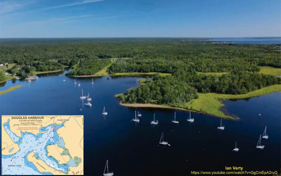
Fossils near Douglas Harbour
During our annual cruise with MYC last year I had invited some Archaeologists to come and help us interpret what we found. They were very pleased with the site.
Field Guide to aid exploring in the Earle’s Meadows Area, Douglas Harbour, New Brunswick
Luke Allen1, Steven Hinds1,2, Eric Phinney3, and Matt Stimson2
- Geological Surveys Branch, Department of Natural Resources, Fredericton New Brunswick, Canada, E2K 1E5
- Steinhammer Paleontology Laboratories, New Brunswick Museum, St., John, New Brunswick, Canada, E2K 1E5
- Martinon Yacht Club, 2 Essex St, Saint John, NB E2M 7B7, Canada

Introduction:
Geological setting (Pangea, Maritimes Basin, tropical swamp)
The landscape in New Brunswick 310-315 million years ago (ma) looked very different than the world we know today. During the Carboniferous Period (360-300ma), New Brunswick was part of a giant super continent known as Laurentia (paleo-North America and parts of Europe). Many of the other continents we know today were accreted into a second super continent known as Gondwana that resided mostly in the southern hemisphere. New Brunswick (Laurentia) was located just south of the equator but both continents were drifting northward (Fig. 1). A collision between the continents began during the Devonian Period that uplifted the Appalachian Mountains that would have been as majestic as the Himalayan or the Rocky Mountains today. Over the last 350 million years, these mountains have eroded as water slowly, over millions of years degrades (denudates) the rocks, grinding them up into sand and mud which is transported in rivers towards the ocean.
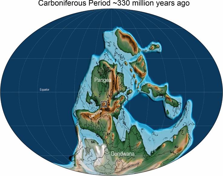
Figure 1: Paleogeographic reconstruction of the Earth during the Carboniferous Period. Abbreviations: SA = South America, AF = Africa, US = United States, NB = New Brunswick, EU = Europe, GB = Great Britain, NC = North China, AU = Australia (modified after Scotese et al., 2024).
At the time, during the Carboniferous period, New Brunswick, all Atlantic Canada, and indeed much of North America was covered in vast tropical swamps that would have resembled a cross between the Mississippi Bayou and the Amazon Rain Forest today. There were no chirping birds echoing through the forests or mammals, grass or flowers. The plant life would be strange and would closely have resembled trees that you might see in a Dr. Suess book rather than a forest today (Fig. 2). These tropical swamps were
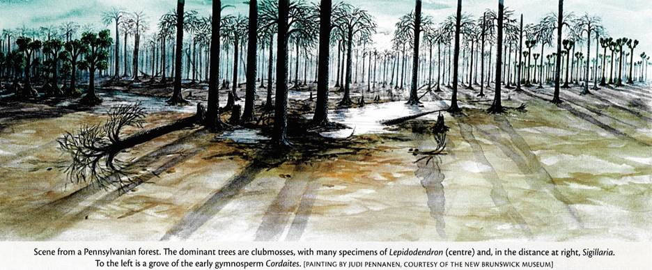
Figure 2: Artist’s rendition of a typical forest during the Carboniferous Period (From Fensome and Williams 2022)
populated with tree-sized “plants” with cheaply constructed architectures rather than true trees as we know them today. The Carboniferous ‘trees’ were essentially held together with a thick outer “bark”, but the inside was composed of spongy water saturated tissued called “parenchyma tissues” (Fig. 3). These trees would grow fast and die just as rapidly accumulating into thick layers of peat at the base of the swamps where the swampy waters were essentially stagnant and anoxic (lacking oxygen). These peats accumulated into thick layers that would later be buried and compressed into the coals that were once mined in the Minto and Grand Lake area.
Rivers flowing from the mountains carried sediments (sand and muds) as part of the river “bed-lode” from the west to the east. During the Carboniferous, Atlantic Canada was surrounded by mountains with vast interconnected river systems flowing to the northeast towards open water. Sediment accumulated between these mountain chains in what’s known to geologists as a “basin”, or an area that accumulated sediments that can later be turned into stone (sedimentary rocks) and sometimes can preserve fossils. In Atlantic Canada, the “Maritimes Basin” extends from the Gaspe Peninsula of Quebec, south crossing New Brunswick and extends into northern Nova Scotia (Fig. 4). The basin extends to the east across the Gulf of Saint Laurence to the shores of Newfoundland and the Magdeline Islands. In this “Maritimes Basin” sediments have accumulated between the Devonian Period (~390ma) to the earliest Permian Period (~290ma) recording about 100 million years of earths history.
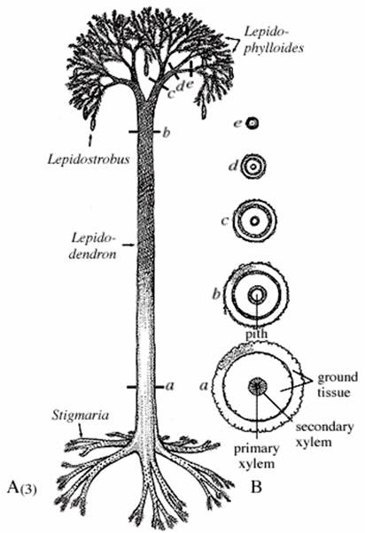
Figure 3: Schematic diagram of Lepedidendron tree (From Eggert 1961)
The rocks in the Grand Lake region of the province record some of this geological history. Deep in the subsurface, below the beaches of Douglas Harbour are mostly Silurian aged (~430ma) sediments of the Flume Ridge Formation that were heated (metamorphic rocks), faulted and folded during the mountain building event that uplifted the Appalachian Mountains. Approximately 311 million years ago, Carboniferous sediments were deposited over the older Flume Ridge Formation within a regionally subsiding (sinking) basin.
At surface, as you walk the shores of Douglas Harbour and Earle’s Meadows, outcrops (places where the bedrock below our feet are visible at surface) exhibit sandstones; sometimes filled with pebbles (known as conglomerates). The sedimentary rocks are part of the Minto Formation, and they range in age from 310-315 ma within the
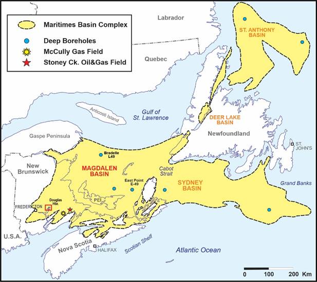
Figure 4: Map of the aerial extents of the Carboniferous Maritimes Basin Complex (modified from Dietrich et al. 2011)
central portion of the province. These sandstones and conglomerates are the result of sediments that were carried from the mountains by fast moving rivers. Pebbles of older rocks that were carried by the rivers have been rounded and smoothed by water action into river gravels just as you can see today if you spend time hiking the rivers and streams around the province. As the grade (steepness) of the river decreased, the water slowed down and could no longer carry sediment and pebbles. The sediment settled to the bottom of the rivers as they snaked across the landscape avulsing back and forth within the flood plain area of the river (Fig. 5). Just as today, river waters would rise, and overtop their banks (levees) pouring water, sand and mud onto the floodplain. As sediments accumulated, layer after layer, the plants and animals that were once living on the shores of these rivers could become buried in sediment. Later, when the sands were buried and turned to stone, these organisms could be preserved as fossils (Fig. 5).
If you walk into a forest today, you may hear birds, bugs, maybe the sounds of mammals walking through the forests. But what you see are plants. Plants make up most of the life in a forest and the same is true for the Carboniferous Period. As a result, most fossils that we see preserved are indeed plant fossils. If you walked through a Carboniferous swamp, the first plants to catch your eye might be the towering Lycopod trees, giant ancestors of modern-day clubmosses (Fig. 3). These trees were up to 1.5 m in
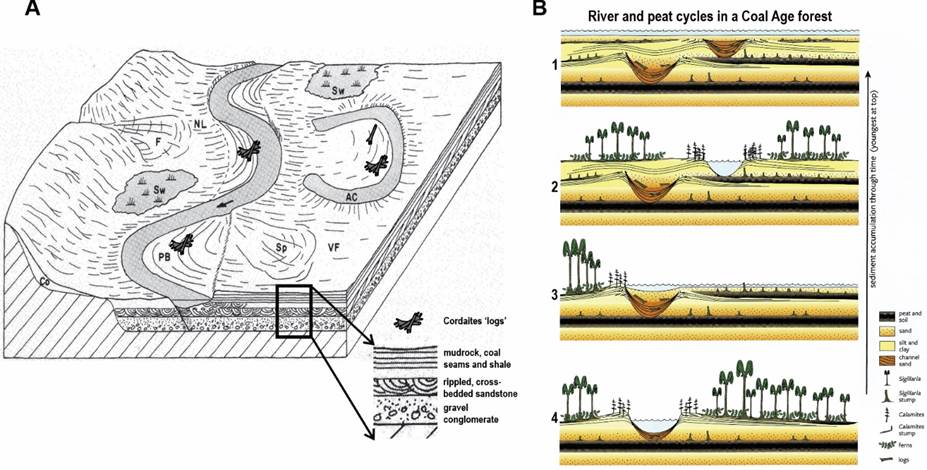
Figure 5: (A) Schematic diagram of a meandering river, Tributary stream at left has built fan (F) onto alluvial plain. NL= natural levee; PB = point bar; Sp = splay deposit; Sw = swamp; AC = abandoned channel (now an ox-bow lake and filling with fine sediments); VF= valley floor floodplain (modified after Friedman and Sanders, 1978). (B) Representing the start of a cycle, 1- a river is shown cutting a channel in older sediments and depositing sand. Calamites is along the flood plain edge with Sigillaria and ferns in wetlands. Organic debris from the forest is building up a layer of peat that may eventually form coal. 2- The river breaks out of its channel during a flood, depositing sand and choking the forest, covering the peat and filling the old channel. Only the stumps of the trees are preserved by the “sheet” sand. 3- A new forest is growing on the flood plain of the new river. Through time, this process builds up repeating layers of peat, sand, silt, and clay. 4- Periodically, the cycle is interrupted by more extensive flooding; during this phase, thin organic-rich mudstone packed with bivalves (clam coals) were sometimes deposited (Modified from Fensome and Williams 2022).
width and grew to be 30 m in height. Despite their size, they were “cheaply constructed” in that the stems were tall but weakly built and would reach a maximum size within about 10 years. The branches and crowns of these trees would be covered in long fine needle-like leaves that would stem from the branches with the occasional cigar shaped cones dangling from the branches between the leaves. The crowns were composed of a series of bifurcating branches that would result in the crowns of these trees looking like two large pom-poms atop a tall stem. The trunk of the tree is eponymous to its name “Lepidodendron” which literally means “scaley tree”. The bark of these lycopod trees were covered in small leaf scares that have interconnected diamond shape patterns along the trunk and branches (Fig. 3). When these trees died, they would break up, and fragments or portions of the stems can often be found preserved as coaly films still identifiable by the scaley patterns preserved within the flood plain and river channel sedimentary rocks.
Below the canopy of pom-pom-like lycopod crowns, grew long and slender stalks of a “bamboo-like” plant known as Calamites (Fig. 6). These plants were giant horsetails, not unlike the modern-day equisetum horsetails that still grown in the ditches of Atlantic Canada and around the world today. The most obvious difference between the two would be the scale. Calamites could grow to heights of 10 m or more with diameters that were commonly 5-10 cm but, in some cases, could reach sizes of up to 20 cm in diameter; a far cry from the 2-5 mm diameter stems of their descendants that live in the Atlantic Canadian swamps today. Ferns in the form of “tree-ferns” up to 10 m in height and ground-hugging herbaceous ferns not unlike the fiddleheads known on the forest flores of New Brunswick today, filled in much of the forested wetland understory. Many species of ferns are known from the Carboniferous of Atlantic Canada, and many are known from the Minto Formation. However, the sandstones and conglomerates of the Douglas Harbour area are far too coarse to preserve the delicate leaves of these plants. The ropy stems of the early tree-sized ferns have been noted amongst the plant stem debris preserved in the sandstone and conglomerates that were once ancient rivers.
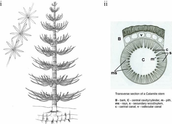
Figure 6: i- Schematic diagram of Calamites tree (Wikimedia Commons image 2017). ii- cross section of Calamites (after Stewart et al. 1993).
More commonly and easily recognized are the “permineralized” logs of giant cordaites trees that can be commonly found along the shores of Grand Lake (Fig. 7). Unlike the wetland trees mentioned above, Cordaites was a hinterland tree that lived in the uplands of the floodplains and river systems on the sides of the mountainous areas upstream. These trees were truly “woody” trees in that if you saw a cross section of the stem, you could count the rings, like the present-day “trees”. These ancient trees had large strap-like leaves that resembled the texture on a corn husk. Both leaves and trunks were often washed downstream by fast moving rivers but where the rivers slowed and began to meander, these logs would become entangled on the meandering riverbanks. The obstacle would then capture other plant stems and debris and gradually slow the velocity of the river (baffling sediment).
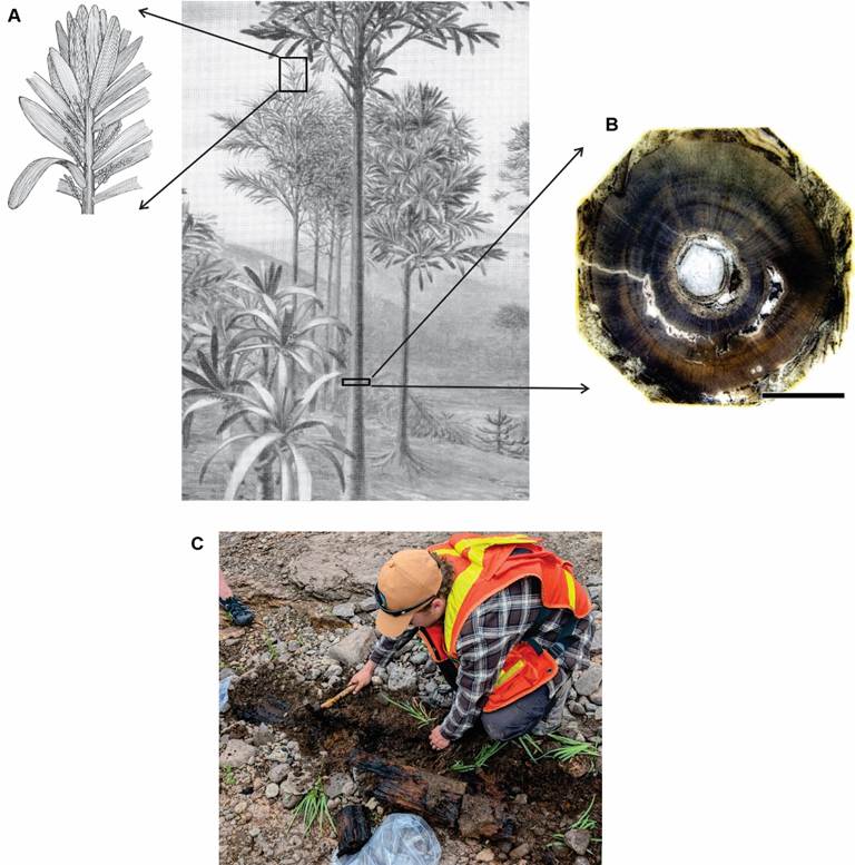
Figure 7: (A) Schematic diagram of cordaites tree and branch details (Modified from Darrah 1960). (B) Cross section of cordaites trunk, note the growth rings (After Taylor et al. 2009). (C) – Fossilized cordaites trunk found on the shoreline of Douglas Harbour (Photo by Matt Stimson).
The river would be forced to change course and meander away and some of the earliest known “logjams” formed, modifying the river landscapes within the Maritimes Basin. These logs are found along the shores as black-coaly cylinders, ranging from one to several metres in length (Fig 5). The original wood has been compressed into coal, but the “airspace” known as “pore space” within the wood has been replaced with new minerals (permineralized). These logs are essentially “half petrified” because the original organics are still present but in the form of coal. These Cordaites logs (wood is known as “Dadoxylon”) are commonly fossilized within the abandoned ancient river channels that are represented by thick gravel conglomerates at the base but grade up into finer sandstones with ripples and “cross-beds” near the top. (Fig. 5).
Elsewhere in the Minto Formation on Grand Lake, fine sediments and shales represent the floodplains of the ancient swamps. Here, delicate leaves of ferns can be found fossilized in association with seams of coal. Due to the low energy, quiescent, stagnant swamp waters, the potential to preserve delicate fossils increases. Wings of insects, delicate trackways of invertebrates (myriapods, horseshoe crabs, cockroaches and beetles) can be found beside the trackways of early reptiles and amphibians. These animals lived and evolved within the swamps, eventually diversifying into many of the groups of animals that exist on the planet today. Although the skeletons and body fossils (except for rare wing fossils) of these animals have not been found in New Brunswick, the presence of these early amphibians and reptiles and invertebrates is only known by their footprints.
New Brunswick Heritage Conservation Act
Although fossils can be found throughout the province, and many of them are common, all fossils in the province of New Brunswick are protected under the Heritage Conservation Act and cannot be collected or disturbed without a Paleontology Research Permit. Despite the impression that these fossils may seem common, some may be a rare species or exhibit new information that can help paleontologist reconstruct these ancient plants and animals, and the world they lived in. New species are being found every year! If you find a fossil, please contact the New Brunswick Museum curatorial staff who can assist with identifying your discovery. You may have found the next important piece of the puzzle or even a new fossil species!
References
Eggert, D. A. 1961. Ontogeny of the Carboniferous arborescent Lycoposida. Palaeontographica 108B: 43–92.
Darrah, W. C., 1960. Principals of Paleobotany, The Ronald Press Company – New York, 295 p.
Dietrich, J., Lavoie, D., Hannigan, P., Pinet, N., Castonguay, S., Giles, P., and Hamblin, A. 2011. Geological setting and resource potential of conventional petroleum plays in Paleozoic basins in eastern Canada. Bulletin of Canadian Petroleum Geology, 59, pp. 54-84.
Fensome R., and Williams G. (eds), 2022. The Last Billion Years – A geological history of the Maritime Provinces of Canada, Nimbus Publishing, 260 p.
Friedman G.M. and Saunders J.E., 1978. Principles of Sedimentology: Chapter 8 – Non-marine environments I, John Wiley and Sons, 792 p.
Scotese, C. R., Vérard, C., Burgener, L., Elling, R. P. Kocsis, A. T., Phanerozoic-scope supplementary material to “The Cretaceous World: Plate Tectonics, Paleogeography, and Paleoclimate (doi:10.1144/sp544-2024-28)” from the PALEOMAP project”. doi:10.5281/zenodo.10659112
Taylor T.N, Taylor E.L., and Krings M., 2009. Chapter 20 – Cordaitales, In: Paleobotany (2nd Ed) The Biology and Evolution of Fossil Plants, Academic Press, p. 787-804
Wikimedia Commons Image 2017. (https://commons.wikimedia.org/w/index.php?curid=56797814) open license (https://creativecommons.org/licenses/by-sa/3.0/deed.en).